
San Juan County
- Dennis Banks.
| facebook | 500px | ferpectshotz |
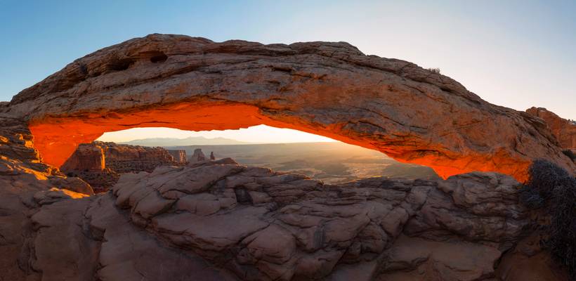
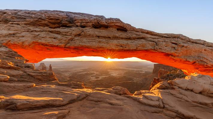
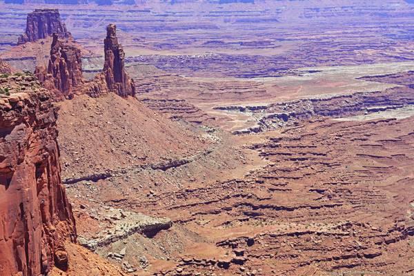
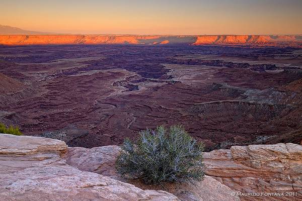
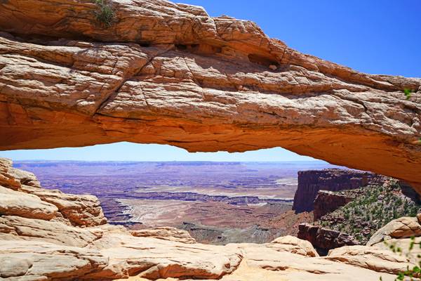
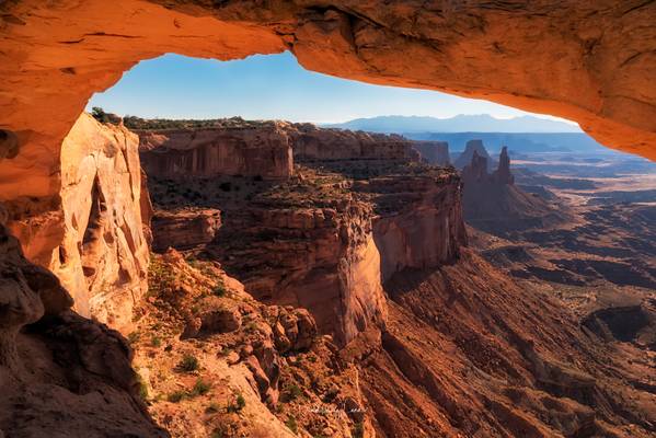
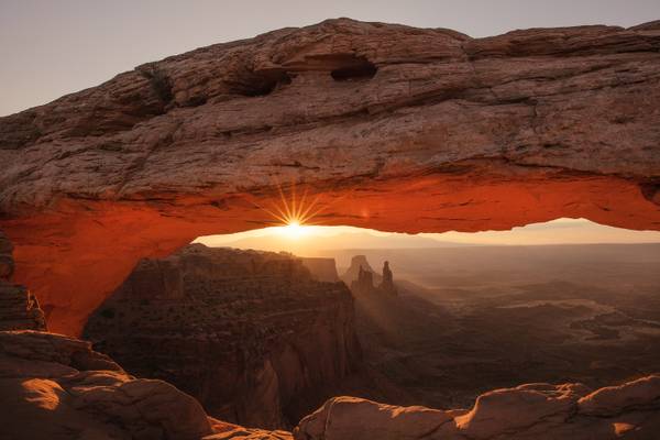
After Bryce Canyon exploration and our brief stint with the cold we went on to Moab, UT. The gateway town to both Arches and Canyonlands-Island in the sky National Parks. On our first day we decided to tackle the popular destinations and visited one of the most famous geological formations, the Mesa Arch of Canyonlands. There is a pretty short hike to get to the arch which is actually not as huge as I envisioned it but spectacular nonetheless. The only problem is the number of people at location, being one of the most photographed locations in Utah and perhaps southwest itself it's pretty popular even on a cold December morning. Thankfully I am early enough to get a decent spot, I heard some photographer to my left camped out in the location since 4 am for a sunset at 7am.
Anyways we had a nice time talking to fellow photographers about the locations and had a blast sharing tips regarding techniques. I made this pano shot once everyone started to leave after the sun burst through the horizon. This is a four shot panorama of the whole arch, with the early morning sun providing amazing light on the valley below.
USA 2011 - Canyonlands
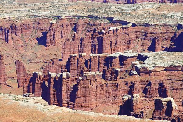
Canyonlands National Park
- Ambrose Bierce.
| facebook | 500px | ferpectshotz |
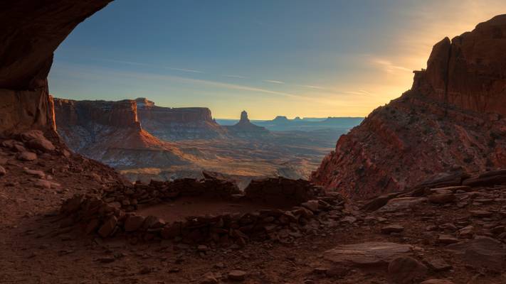
One of the locations I was keen to visit during our December trip to Utah was the stunningly beautiful False Kiva site. I read a bit about the hike and it seemed pretty manageable added to the fact that we will be doing the hike in winter and not under the searing hot summer sun. When I looked at maps, it looked like this location was not ideal place for sunset as the canyon walls to the right will block any light putting the whole location in shade. So we decided to head out there early evening and get back to the car while there is still some daylight out there.
Turns out, this was an excellent decision, as the hike turned out to be much harder than expected. First of all the snow on the ground have covered any previous tracks. Add to that the trail seems to disappear over a small cliff and then seem to resume at the bottom of the cliff. Guide books talked about looking for kairns to find a relatively easy path down the cliff, but the snow made them almost impossible to find. We even ran into a Japanese photographer who gave up and went back. But with a trusted trail map we persisted and scampered down to the bottom of the cliff. From where there was a casual stroll for a bit before we came across what looked like a field of fallen boulders. The next stage of the hike was climbing over a multitude of rocks and boulders to reach the bottom of the cave that is false kiva. Then we had to basically inch our way up and finally climb over a giant boulder to get to the location.
Once we reached, the view was absolutely phenomenal. I managed to get this shot while the sun was fairly high up in the sky but was lighting up the canyon wall in stunning light. So I sacrificed some highlights for a detailed shot of the awesome False Kiva.
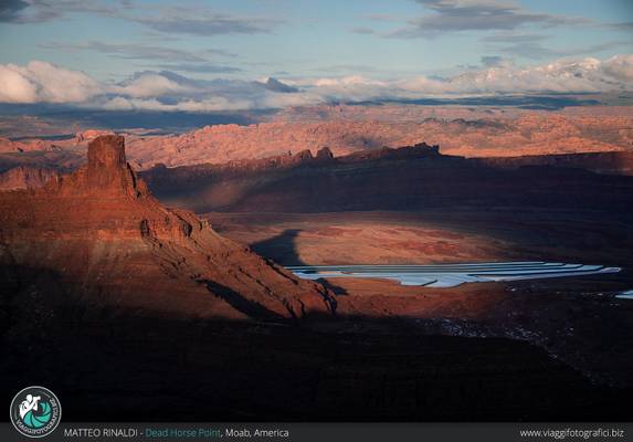
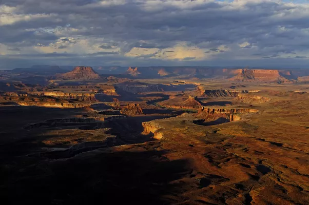
"giocando" con le luci sui canyon sottostanti al Dead Horse point, in attesa del tramonto... che poi non si è visto perchè è svanito dietro alle nuvolte. Ma sicuramente anche questi istanti sono stati molti belli.
Scatti realizzati durante il viaggio fotografico con www.viaggifotografici.biz attraverso i parchi Americani dell'Ovest.
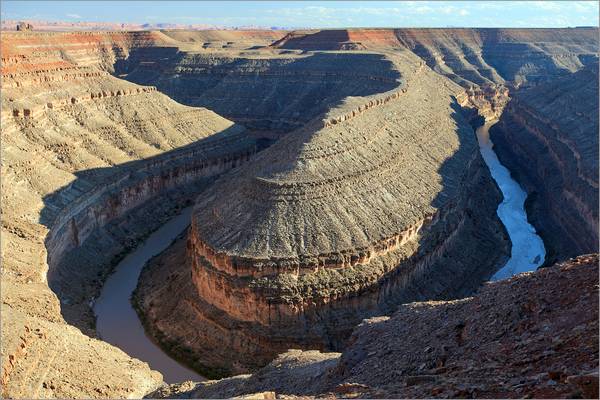
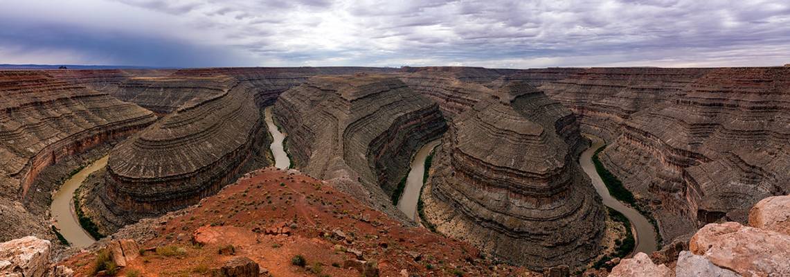
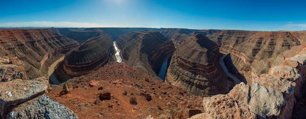
Goosenecks State Park is a state park in the U.S. state of Utah, overlooking a deep meander of the San Juan River. The park is located near the southern border of the state a short distance from Mexican Hat, Utah.
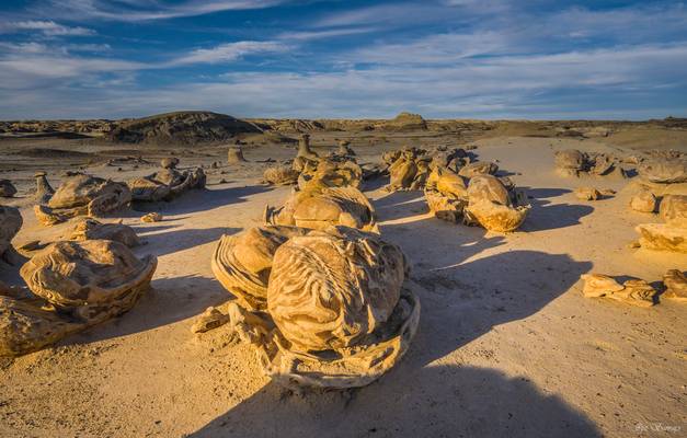
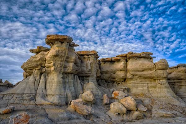
Cracked eggs at Bisti badlands
- Voltaire.
| facebook | 500px | ferpectshotz |
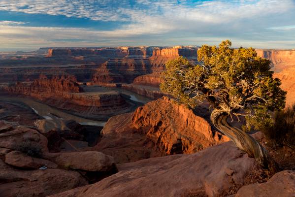
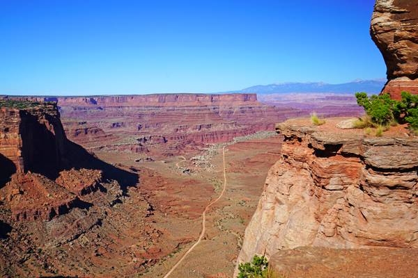
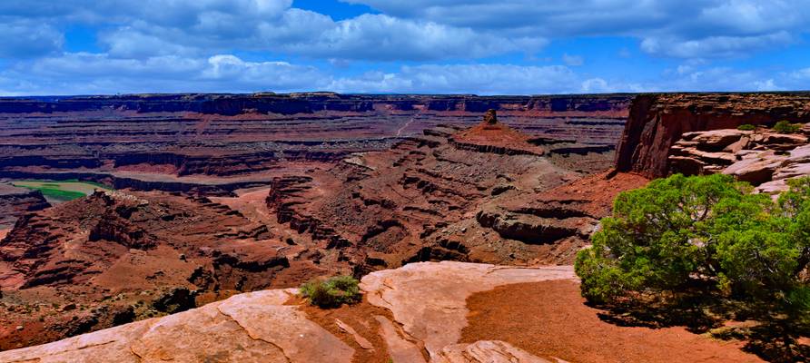
One of the coolest things you can do at Dead Horse Point state park in Eastern Utah is to check out the canyon rim to find Trees with interesting shapes. It’s especially thrilling to do so while the sun is rising and you are short on time and you have a heavy camera and tripod to lug around and jump around near cliff edges. Great fun when you consider the fact that the canyon rim is at an elevation of 5,900 feet.
Anyways, after scaring myself half to death, I came across this beautiful tree which had a shape that perfectly complemented the shape of the canyon. Thankfully I also had great luck with the light but the clouds didn’t cooperate as much. Hopefully, someday I get to come here again when the sky is spectacular.
USA 2011 - Canyonlands
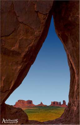
Being in Monument Valley in early December I was informed the sun doesn't hit Teardrop Arch at that time. I still wanted to see it though. Once there, I realised the next challenge was not being tall enough to peep through the hole, and not having a tripod that goes up so high. So this is a manual shot, with the camera held high above my head, and I'm quite pleased with how it turned out :-)
This Raven followed me around as I went from site to site early in the morning. I got lucky when photographing Rinconada when it flew directly into the center of the frame. I was ready with the finger!
Dead Horse Point State Park is a state park of Utah in the United States, featuring a dramatic overlook of the Colorado River and Canyonlands National Park.
- Edward Hopper.
| facebook | 500px | ferpectshotz |
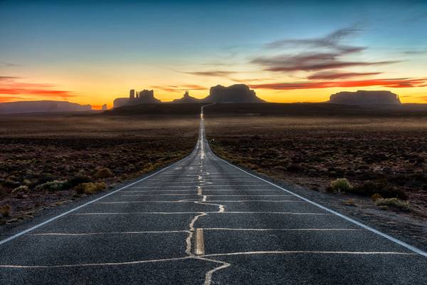
After our hike of antelope canyon we decided to try our luck and head back to monument valley, to get one more sunset shot. I had this location in mind for sunset but we slightly under estimated the distance and only reached here after sunset. When we reached at the famous 13 mile marker, it was almost completely dark with only a bit of light remaining in the far western sky.
It’s really hard to make sunset shots when it’s dark all around but you still have to use ND grad filters. This was the best shot of the bunch and it was a bit of work to get the foreground to brighten up. Thank you for visiting hope you enjoy the picture..
- Martin Luther.
| facebook | 500px | ferpectshotz |
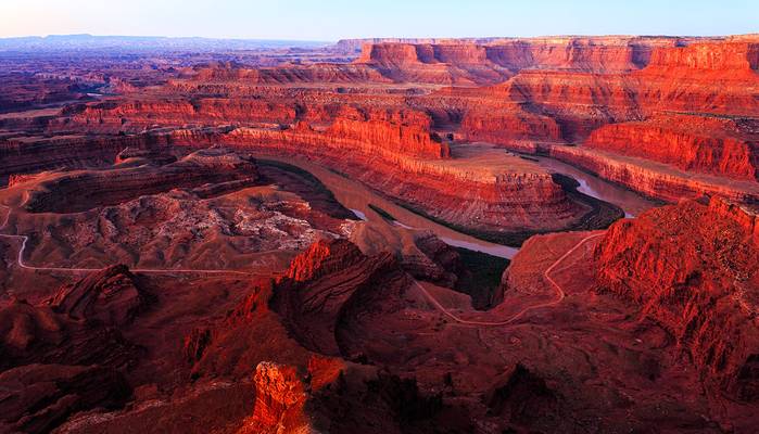
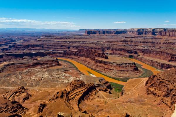
When we started our road trip to Utah, one of my missions was to see all the horseshoe bends which it was famous for. I had visited the original horseshoe bend in Arizona several times so wanted to see other locations in southwest where the river does the same thing. There are multiple locations within Utah where this happens actually. There is goosenecks overlook near Capitol Reef where Sulpher creek does a horse shoe bend. Then there is the Dead Horse Point state park where the Colorado river does some spectacular turns.
But the real stunner is the Goosenecks state park close to monument valley. Here the San Juan river is twisted around to roughly 25 horseshoe bends within a couple of miles (I counted by zooming into the location on google maps), even though only about 5 is visible from the view point. This is pano shot I created at the park, one of the rare moments I wished I had access to a drone.
View of the Colorado River from Dead Horse Point Overlook, (DSCN1583)
Esta frase está sacada de una entrevista que le hicieron a Pau Donés mientras le plantaba cara a la enfermedad que se lo llevó por delante:
"-¿Tienes miedo del futuro o prefieres vivir el presente y tirar para delante?
No quiero que mi presente sea el tiempo que pierdo pensando en el futuro, porque el futuro no existe. Vivir es urgente, así que vivamos el “ya”. Desde siempre vivo el presente con la mayor intensidad posible. En el libro (50 PALOS) hay un capítulo donde lo cuento bien."
Muchas veces no somos conscientes de lo que tenemos hasta que lo perdemos. Vivamos la vida y disfrutemosla intensamente.
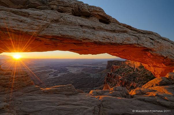
Mesa Arch Canyonlands National Park, Moab, Utah, United States September 2016
Front Page Perfection In Pictures Sept 2020
- Sophocles.
| facebook | 500px | ferpectshotz |
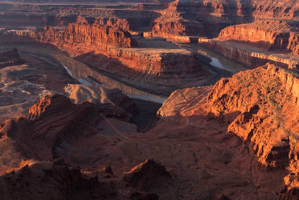
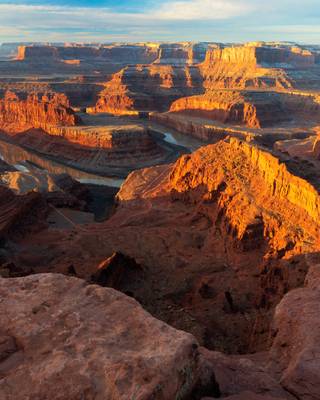
Here is another shot from the stunning Dead Horse Point State Park, near Canyonlands and Arches National parks. Because of the proximity to such illustrious and stunning National Parks this wonderful little state park get much fewer visitors. We scheduled it for sunrise on the day we were to drive home. Needless to say, we were late by a couple of hours to get home.
In this shot, I tried to just look for the sheer magnificence of the canyon, avoiding any distractions in the foreground, just a regular tourist shot taken with the best possible light. I also tried to avoid adding in any part of the sky just to focus on the stunning beauty of the Dead Horse Canyon and the Colorado River.
- Emily Dickinson.
| facebook | 500px | ferpectshots |
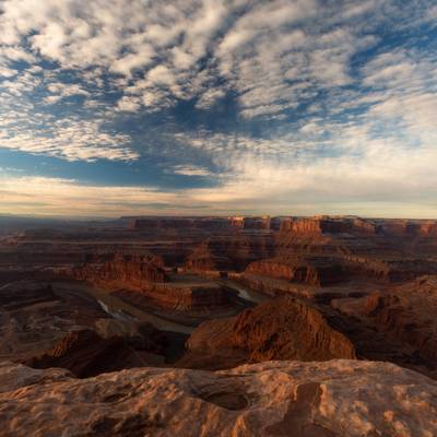
With today's shot, I want to make a case for getting off the bed early to watch scenic vistas in the beautiful light of the morning golden hour. To the uninitiated, the golden hour happens about an hour after sunrise and an hour before sunset. During this time, the light is exceptionally warm in color tone bringing landscapes to life. Since the sun is at its low orbit, the light also tends to come from the side rather than overhead and side lighting is more flattering than the overhead variety. If you have any doubt, check next time a wedding or portrait photographer set up their light for a photo shoot.
As a landscape photographer, the side lighting and the warm tones are invaluable as there is no way to recreate them by any sort of artificial means. While I tend to agree with Forrest Gump's statement that “And then in the desert, when the sun comes up, I couldn't tell where heavens stopped and the earth began” its hard not to let the colors overwhelm the composition. Sunrise, on the other hand, provides a more subtle version of the same conditions, which helps in telling your story in a better way. In general, the scene has natural warm colors. I tend to prefer to shoot it in the morning and if it has colder tones then during sunset. There are other elements like the direction of light and elevation that often influence this decision, but that’s a topic for another day. Meanwhile, I hope you enjoy this beautiful sunrise at Utah’s Dead Horse point State Park.
- William Butler Yeats.
| facebook | 500px | ferpectshotz |
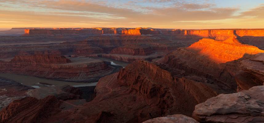
Today’s phot is a from one of my favorite locations in all of American Southwest, Dead Horse Point State Park. We were at Moab, UT as part of our 10-day long roadtrip across most of the Southern Utah. We passed this little state park on our way to Canyonlands National Park everyday. During our planning we only allowed a sunrise slot to this park because I knew that there was only really one composition here.
I am glad to report that this little statepark proved me very wrong, while it has only one composition what composition it is. We were quite blown away by the grand scene that unfolded in front of us during sunrise. Also, the sheer amount of foreground interests to compose at the park is just tremendous, all you must do is safely traverse to the ledge while keeping in mind about the sheer drop to the canyon.
This is a panorama shot made of stitching two images taken in landscape orientation. I used a 2 stop ND grad filter to balance incredible light in the sky and some of the cliffs to ambient light in the canyon. I also used a bit of the canyon ledge to provide some perspective to the sheer size of the canyon the Colorado river has created.
Everything about this photo looks warm, but standing there early in the morning at -10°C it was probably the coldest photo I ever took. I had been hoping for some more colour in the sky, but was still pleased with the warm glow of the landscape. Looking down you can see the Shafer Trail, one of the highlights of my previous visit some years earlier.
- Alfred Sisley.
| facebook | 500px | ferpectshotz |
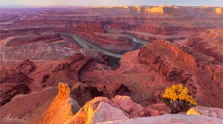
When I told one of my photog friends that we are doing a south Utah road trip and were planning definitely to stop by at Moab. He told me not to overlook the Dead Horse Point State Park which is located just before the entrance to the Canyonlands National Park. I kept that advice in the back of my mind and while in Moab duly got seduced by the much-coveted spots in Arches and Island in the sky national parks.
So when we decided to get an early start on our final day, we decided to one more sunrise shot before leaving and decided to try out the tiny state park. And boy did it turn out to be a great decision, this tiny speck of land in southeastern Utah is beautiful beyond words. We learned that the unusual name of the park comes from the fact that it was used as a natural corral by cowboys in the 19th century, where horses often died of exposure. We had a perfect sunrise that day with stunning red cliffs getting saturated by bright warm morning light. This shot is a vertical panorama I shot of the main viewpoint. Hope you all enjoy it as much as I enjoyed this stunning park.
at New Mexico badlands
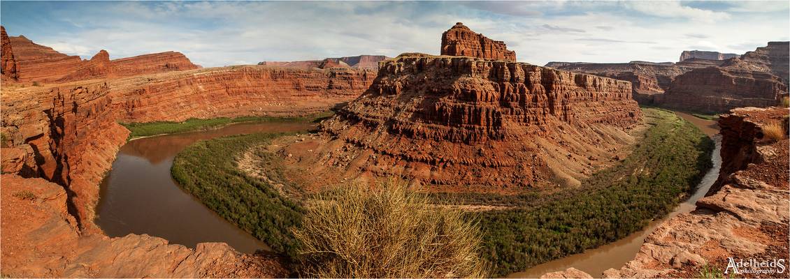
This section of the Colorado River lies in Utah along the Shafer Trail. It is sometimes also referred to as Thelma and Louise point. A stitch of 4 horizontal images.
The Bisti Wilderness area is a rolling landscape of badlands. Time and natural elements have etched a fantasy world of strange rock formations made of interbedded sandstone, shale, mudstone, coal, and silt. The weathering of the sandstone forms hoodoos - weathered rock in the form of pinnacles, spires, cap rocks, and other unusual forms. Fossils occur in this sedimentary landform. Translated from the Navajo language, Bisti means "a large area of shale hills."
Excerpt from www.blm.gov/visit/bisti-de-na-zin-wilderness
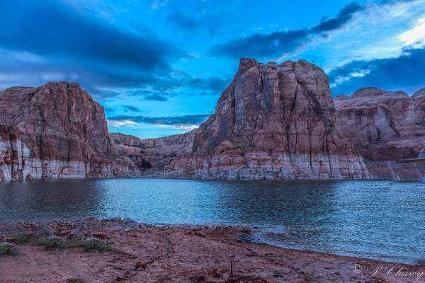
Cliffs were massive, across the lake in the the canyon barely visible is a 80 foot houseboat
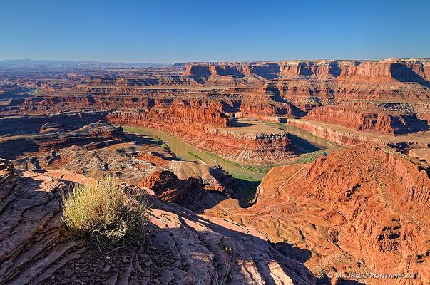
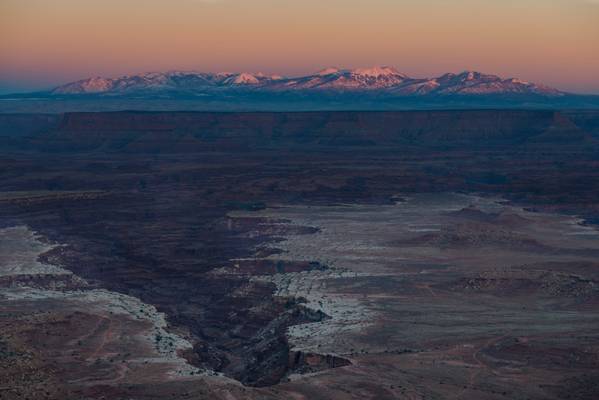
USA 2011 - Dead Horse Point
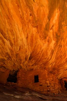
I just couldn't miss this location on my trip. A famous spot where morning sunlight gets reflected by sandstone to create an illusion of an house in red flames. Nice spot to enjoy, particularly if you're lucky and are alone here!
WESTWORLD es el nombre de una sensacional serie de HBO, catalogada como distópica: término opuesto a utopía.
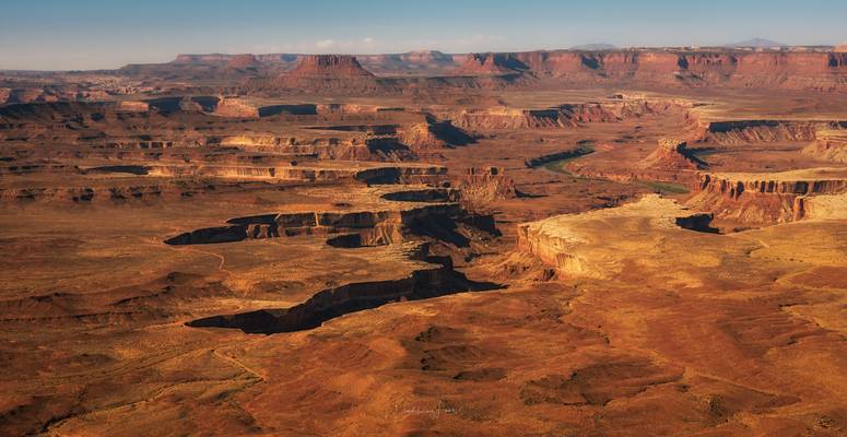
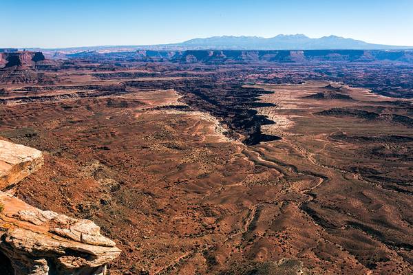
Fuera de términos literarios, este escenario es del parque nacional de Canyonlands, en Utah, Estados Unidos. Este escenario ha sido el marco de diferentes películas, como Thelma y Louise.
El parque nacional de Canyonlands está representado por un relieve lleno de color que se ha erosionado en incontables cañones, mesas y buttes (cuellos volcánicos) por el río Colorado y sus afluentes, como el río Verde. Los ríos dividen el parque en cuatro zonas: 'the Island in the Sky', 'the Needles', 'the Maze' y los ríos. Los cuatro comparten una atmósfera desértica, pero cada uno tiene sus propias características.
Esta imagen está hecha desde 'the Island in the Sky' y lo que vemos son los meandros del Río Verde. El escenario en conjunto me recuerda mucho a la serie 'WestWorld' por eso la he titulado así.
WESTWORLD is the name of a sensational HBO series, cataloged as dystopian: a term opposite to utopia.
Outside of literary terms, this landscape is from Canyonlands National Park in Utah, United States. This place has been the setting for different films, such as Thelma and Louise.
The park preserves a colorful landscape eroded into numerous canyons, mesas, and buttes by the Colorado River, the Green River, and their respective tributaries. The park is divided into four districts: the Island in the Sky, the Needles, the Maze, and the combined rivers.
This image is made from 'the Island in the Sky' and you can see the meanders of the Green River. The stage as a whole reminds me a lot of the series 'WestWorld' that's why I have titled it that way.
The Island in the Sky Canyonlands National Park, Moab, Utah, United States September 2016
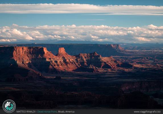
"giocando" con le luci sui canyon sottostanti al Dead Horse point, in attesa del tramonto... che poi non si è visto perchè è svanito dietro alle nuvolte. Ma sicuramente anche questi istanti sono stati molti belli.
Scatti realizzati durante il viaggio fotografico con www.viaggifotografici.biz attraverso i parchi Americani dell'Ovest.
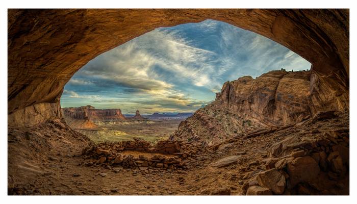
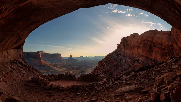
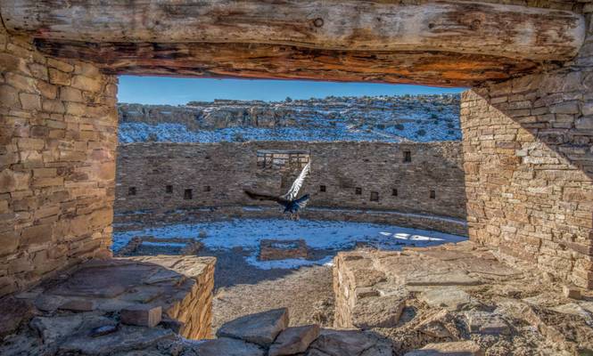
7 shots with 24MM stitched together. I exposed for the sky and "dug out" the shadows. The D800E has incredible DR. This is a very special spot. I have had it on my bucket list for some time. It's not on any park map but if you ask the rangers for directions they will help you get there. Please be respectful as this is an active archeological site.
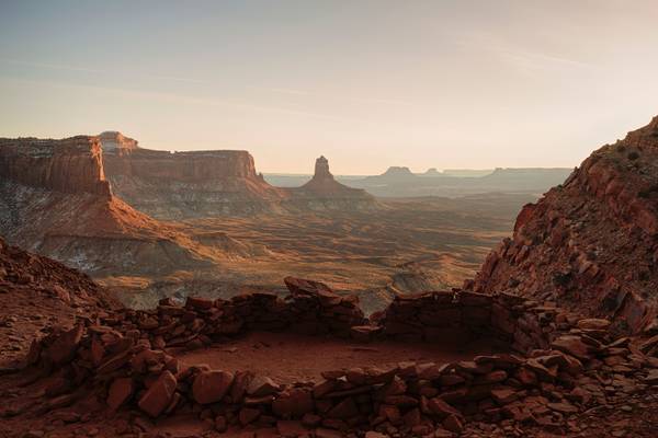
- Buddha.
| facebook | 500px | ferpectshotz |
Another shot from the majestic false kiva of Canyonlands National park. I don’t have words for how beautiful this site is and how much the hard scrambling hike contribute to the beauty. To be honest this site was one of the reasons why I zeroed in on Island in the sky part of Canyonlands over other sections. And the park didn’t disappoint, this is an absolutely gorgeous piece of land, I am glad I got to visit and experience the park.
For this shot, I used a slightly longer focal length to get the far away canyon walls more prominence and get the really gorgeous light coming in from the right lighting up the walls properly. If you have a chance add this park to your list and make the hike to false kiva a priority. Just be careful.
Canyonlands National Park
- Thomas Fuller.
| facebook | 500px | ferpectshotz |
One of the coolest locations that we have ever visited during our many trips to the American southwest is the false kiva at Canyonlands National Park. The trail to this beautiful location is barely marked and is almost impossible to find. We met two other hikers on our quest to find the trail who gave up and went back to their cars. Once we found a couple of trail cairns we were overjoyed but soon it looked like the trail dropped off a canyon cliff. It took me about 20 minutes to finally figure out that the trail actually turns sharply right from the cliff and while it looks daunting from the top its actually not the hardest part of the trail. The hardest part came when we had to navigate a bit of a boulder meadow full of rocks the size of a smart car. It took us way more time than we planned to get over the boulder field and finally to climb to the small cave that contains the false kiva.
While the trail was hard and difficult to navigate, the view from the kiva more than made up for the difficulties we experienced. While we didn’t quite stay till the full sunset, I got this shot with some fantastic details of the kiva and some great colors in the sky. Technically I find cave shots to be one of the hardest shots that I have to take and this image, not an exception. I had a hard time balancing the bright sky with the darkness of the cave and the false kiva. So this image is a composite of three images. The first one was taken to show off details of the cave and the second one with a 2 stop nd grad and exposing for the sky and the sunset and a third image where I did average metering of the whole scene with a bit of exposure compensation added to get the histogram correct. I blended my three images using a bit of exposure blending techniques by incorporating luminosity masks rather than using an HDR software. I think I am much more satisfied with luminosity masking than most HDR software that I have used.
- Ovid
| facebook | 500px | ferpectshotz |
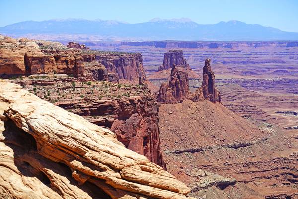
While we were at Moab, UT one of the sights that struck us the most was the mighty La Sal mountains to the east. They are omnipresent from every location and their snow-capped peaks provide the right background for many of the iconic shots of the nearby Arches and Canyonlands national parks. So while we were there me and my wife decided that we need a shot that will truly capture the majesty of these peaks without many distractions and we kept an eye open for interesting framing options.
While looking for interesting hiking options I came across this beautiful spot near Buck Mesa overlook at the Island in the sky section of Canyonlands National park. This location is a very short stroll away from the parking lot but provides a stunning view of the La Sal mountains and the white rim road along with the massive canyon the Colorado River has made. Basically what we are seeing here in the foreground is a stunning former seabed. I returned to the location later to get that beautiful after sunset glow and was not disappointed. One of my favorite shots from the trip.
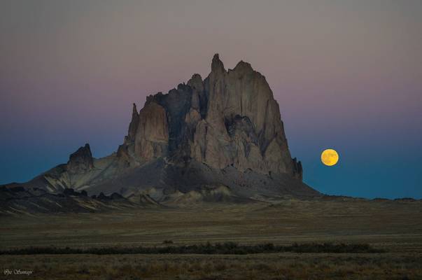
Shiprock, with its wings (also known as Winged Rock), is the remnant of an explosive volcanic eruption that occurred around 30 million years ago, and a monadnock rising nearly 1,583 feet (482.5 m) above the high-desert plain of the Navajo Nation in San Juan County, New Mexico. Its peak elevation is 7,177 feet (2,187.5 m) above sea level.
Governed by the Navajo Nation of native American, the formation is in the Four Corners region and plays a significant role in the religion, myth, and traditions to the Navajo people. It is the most prominent landmark in northwestern New Mexico. In 1975, Shiprock was designated as a National Natural Landmark by the National Park Service.
--Excerpt from Wikipedia
Note: tried the app PlanIt, and managed it to show me the time and location when/where moon will rise. Somehow I doubted about it. I was wrong. The moon rose exactly from the location PlanIt showed. What an amazing app :-)
Thanks to all Phoide contributors to San Juan County!
Most notably Sandeep Thomas, Andrey Sulitskiy, Maurizio Fontana, Yi Jiang, PZ Sunrays, Jiri Hajek, Adelheid Smitt and Matteo Rinaldi.