
Jefferson County
- Bhumibol Adulyadej.
| facebook | 500px | ferpectshotz |
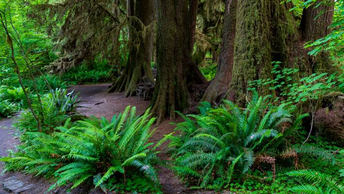
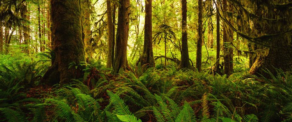
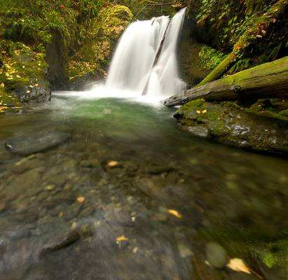
One of our absolute favorite places from the Washington trip is the Hoh rainforest. It was a pain to reach as the entry point to the forest is located all the way on the other side of the peninsula from Port Angeles. This made the drive to the forest brutal and so we had to limit our hikes to the small trails. But once we started the hike, we realized how amazing this enchanted forest can be. We were in love with the greenery around us and rejuvenated just wandering around.
This panorama shot was one of my favorite shots from our short incursion into the forest.
- Charles Dickens.
| facebook | 500px | ferpectshotz |
One of the key attractions of the Olympic Peninsula is the wonderful Hoh rain forest and the stunning loop trails that allow you to explore this amazing ecosystem. Growing up near a Tropical rainforest this was my first experience with a temperate rainforest and I was excited to check out the similarities and differences.
The NPS offer three well maintained trails here that can be taken to explore the rainforest at your own pace, due to the time constraints we took the Hall of mosses train which is about a mile long. There are two other trails, the Spruce Trail which is about 1.2 miles long and the Hoh River Trail which is about 17 miles long. We really hope to come back and do the other two trails someday.
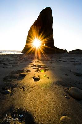
I underestimated the distance we will have to cover to get to the entrance of the forest to our hotel room in Port Angeles and this was the first spot during the trip where we seriously wished for an RV as the next day we had planned to go for sunrise at hurricane ridge. So, we had to cancel our plans for a sunset at Ruby beach and head back early to get some shut-eye.
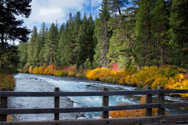
October color along the river.
The Metolius River flows 28.6 miles (46.0 km) from Metolius Springs through the Deschutes National Forest, emptying into Lake Billy Chinook and ultimately the Deschutes River. The upper 11.5 miles (18.5 km) of the river are popular for catch-and-release fishing, whitewater rafting, picnicking, and camping. The lower 17 miles (27 km) are on the boundary of the Warm Springs Indian Reservation, and flow by "a primitive area where motorized vehicles are not allowed."
The Metolius River was officially designated a National Wild and Scenic River in 1988.
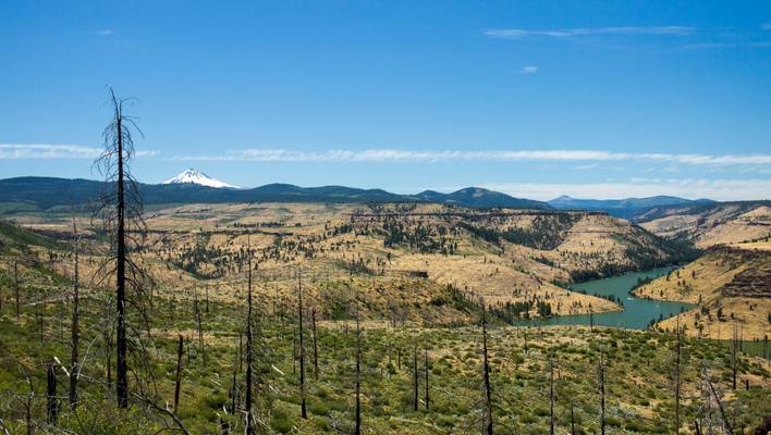
That is Mt. Jefferson in the background, and the west end of Lake Billy Chinook.
The Central Oregon region covers approximately 7,833 square miles (20,290 km2), and sits at the convergence of the Basin and Range, Cascades, Blue Mountains, and Columbia River Plateau geologic regions. Because it is part of a historically volcanic region, volcanic rock formations are a common sight, including lava beds, volcanic buttes, crater lakes, volcanic plugs, and lava tubes.[3] Consequently, Deschutes is the most cave-rich county in Oregon with over 500 lava tubes.
The primary river flowing through Central Oregon is the Deschutes River. Its source is Little Lava Lake in the Cascade Mountains, northwest of LaPine. The Deschutes runs south to north, eventually flowing into the Columbia River. Along its way, dams control its flow creating Crane Prairie Reservoir and Wickiup Reservoir. The river runs alongside the resort community of Sunriver and through the city of Bend.
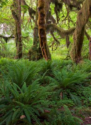
Another of my tilt shift panorama images from my short visit to the Hoh Rain Forest in Olympic National Park. It was such a wonderful place to...
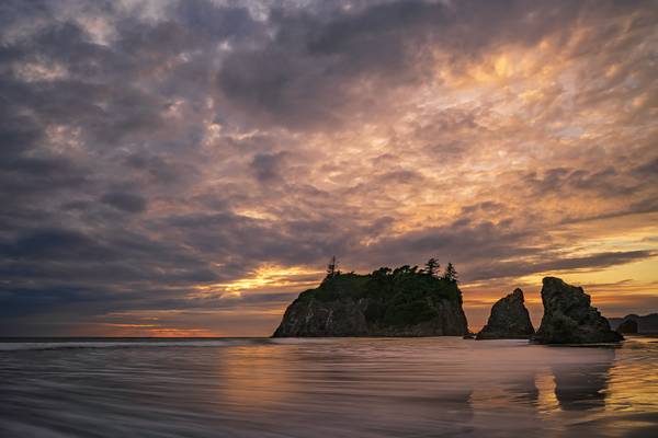
Sunset on the Washington Coast at Ruby Beach. The sun tried to put on a show, but the typical low level clouds put an end to it!
Alright, I finally have some new stuff to show you! This is from our first of 4 evenings on the Olympic Coast. Ruby Beach was our first stop. New...
Here's another from Three Fingered Jack a couple months ago. Hard to believe it's already spring!
- African Proverb.
| facebook | 500px | ferpectshotz |
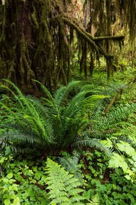
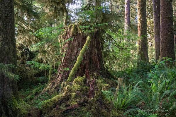
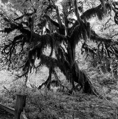
Another shot from the beautiful Hoh Rainforest and the hall of mosses trail. The trail starts innocently enough until you come across the old big leaf maple trees that’s covered in moss and provide the visitor with some otherworldly visuals. The mosses on the trees do not damage the trees. However, the trees can fall by the winds in storms because of their shorter roots due to the abundance of nutrients and water in the forest. Many trees and mosses grow from and over the fallen tree trunks.
Along the trail there is a side path of 200 feet that leads to a grove of maple trees covered with epiphytic spikemoss (Source: Wikipedia). While planningvise this location was hard to reach I think my wife and I agree that we would need to come here again and allocate more time to this stunning rainforest to do it more justice.
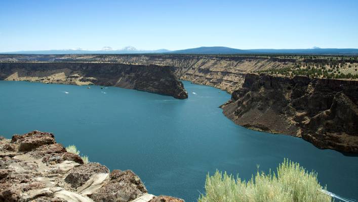
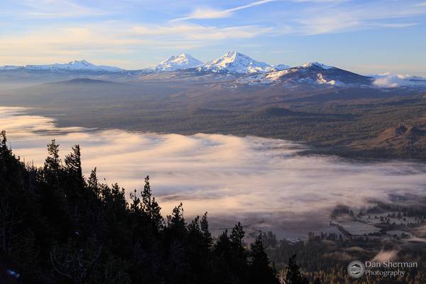
Lake Billy Chinook is a reservoir in Jefferson County, Oregon. Created by the Round Butte Dam in 1964, Lake Billy Chinook lies in a canyon at the confluence of the Crooked, Deschutes (da - SHOOTS) , and Metolius (ma TOLE ee us) rivers near Culver and Madras. It was named for Billy Chinook, a Native American of the Wasco tribe who traveled alongside American explorers John C. Frémont and Kit Carson in their expeditions of 1843 and 1844.
From this area you can see the prominent mountains of the Oregon Cascades in the distance.
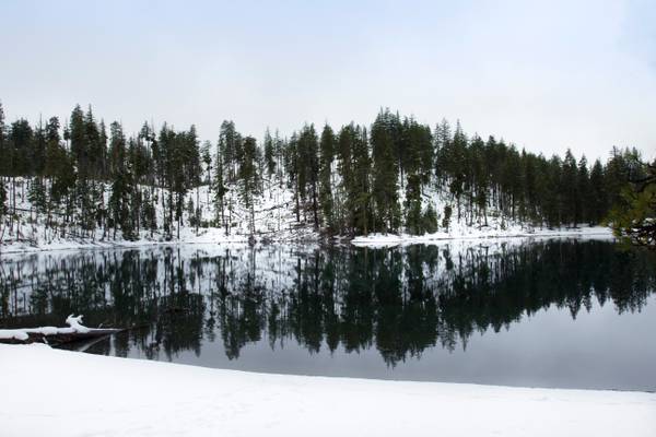
The Cascades received a nice spring snow this past week. Of course, no one can go skiing, but cross country is still okay. A lot of these little lakes are virtually untouched right now.
If you are looking for an idyllic lake for swimming in Central Oregon, there really is no better option than the scenic Scout Lake located in the Deschutes National Forest.
Located south of Suttle Lake in a mixed conifer forest, Scout Lake sits at an elevation 3,700 feet. The deep flowing waters coupled with its sandy shores, make this small pristine lake ideal for swimming as the weather heats up.
The lake features a picturesque shoreline, clear water of aquamarine color surrounded by thin forest of green fir trees that survived in the largest fire in Deschutes Forest history and burned stands of once alive trees. The lake has shallow and deep zone. The shallow water near the sandy beach is perfect for kids wading or splashing.
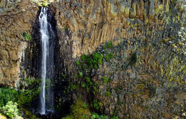
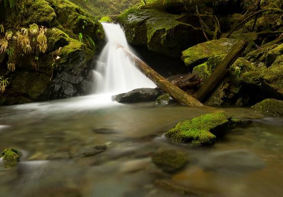
There are two substantial waterfalls in The Cove Palisades State Park, this is the most easily accessed, but smaller of the two. The falls occur where a small unnamed drainage, mostly fed by irrigation runoff, plunges 160 feet off the lip of the Crooked River canyon towards Lake Billy Chinook below. The main road accessing the park passes near the top of the falls and again crosses below it, offering several vantages. The stream along which this waterfall occurs would naturally be an ephemeral watercourse but the extensive agricultural activity along its course has allowed it to essentially come to life when it would otherwise be dry. Expect the falls to be flowing at their best when irrigation activities are at their peak in the early to mid summer months.
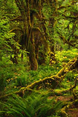
Ferns cover the forest floor, the moss covers everything else. The Hoh Rainforest is an enchanted place.
I am so terribly, horribly & madly in love with this image, I have nothing else to say about it. Imagine that.
My Facebook Page | Twitter |...
Before bushwhacking down to the lower creek, I took this shot of a drop right below Murhut Falls in the Olympic Peninsula. I've always had a...
Olympic National Park, Washington
- Blaise Pascal.
| facebook | 500px | ferpectshotz | buy |
COLOR version of this image
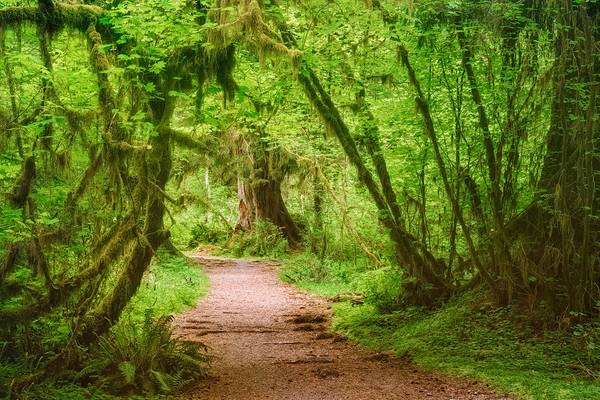
One of the coolest places we got to visit during our road trip to Washington was the hall of Mosses trail at the Hoh rainforest. The trail is pretty short and even but the trees are quite magnificent and at the same time little intimidating. We were there on an afternoon and pretty much had the whole section of the trail to ourselves.
One of the challenges in my photography is taking compelling images of trees. I have precious few images in my stream where single trees are the mail subject. As I was at the Hall of Moses trail and among some of the most majestic old temperate trees including bigleaf maples and Sitka spruces, I had pretty much no idea regarding how to capture them.
This image is a stitch panorama shot of about 3 images that were later cropped to a square crop. While I was processing the image, I noticed that the image felt rather bland with strong green tones overpowering every other visual element in the image. So just for kicks, I desaturated the image completely and I felt instantly great about the shot. Add in some minor contrast adjustment and I feel like the image looks way better than the original. I am curious to know what everyone else thinks about the image.
- Confucius.
| facebook | 500px | ferpectshotz |
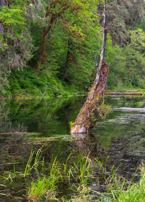
As we were coming out of the parking lot for the Hoh rainforest, I noticed this little lake that looked like a flooded meadow. There were remnants of old trees that were sticking out from the incredibly still and clear water. I knew it was rare to get that level of stillness in the water at sunset, so we parked the car by the roadside and I tried my best to get a good picture of the rotting tree that fascinated me. We didn’t have much time as the sunlight was fading fast and I wanted to bring the vividness to the image.
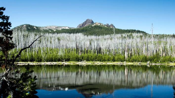
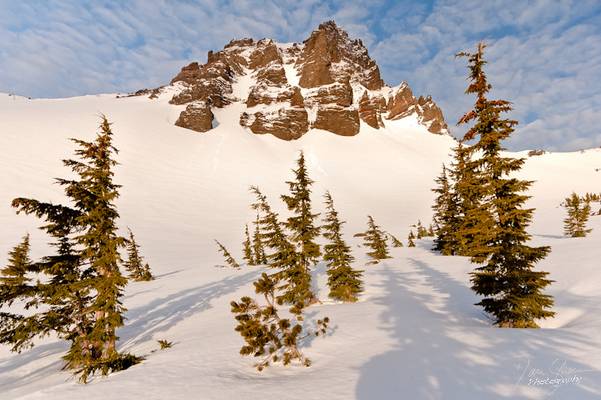
Three Fingered Jack in the background.
Jack Lake is a small lake that sits at the trailhead for the Canyon Creek Meadows trail which leads to the base of Three Fingered Jack. Jack Lake is in the Jefferson Wilderness near Santiam Pass and is about a 30 minute drive from Sisters, Oregon. The lake is at the end of a long and bumpy dirt road that does not require 4×4 but would be helpful. The lake is at an elevation of 5150ft.
Three Fingered Jack lies in Linn and Jefferson counties. It has a volume of 2.4 cubic miles (10 km3) and a summit elevation of 7,844 feet (2,391 m), with a proximal topographic relief of 1,300 feet (400 m) and a draping relief of 4,600 feet (1,400 m). Its jagged edifice rises between Mount Jefferson and the Three Sisters volcanic complex. Three Fingered Jack lies within the Mount Jefferson Wilderness and is not accessible by paved road, but can be approached by the Pacific Crest Trail. Located about 20 miles (32 km) northwest of the city of Sisters, it acts as a prominent landmark in the area.
I have just returned from an awesome 2 week trip to the west coast of the USA. We started in the Olympic National Park and then went down all the way to San Francisco. So there are a lot of photos I'll have to show you over the next weeks.
I'll start with a picture I took in the Hoh Rainforest. Well I expected a lot of this place and it is really beautiful. But during sunshine it's just awefully hard to capture it's magic. I had hoped for some rain there but got only clear blue skies. What made this even worse was the fog at the coast. We were staying in La Push since I wanted to shoot the awesome seascapes of the olympic national park, especially second beach. From the morning of day two fog rolled in and had the whole coast there in it's grasp.
I was fooled twice by the thick cloud cover and headed to the Hoh just to arrive there for the sun to blast all fog and clouds away, leaving only clear blue skies and harsh direct light. This photo I took in the 5-10 Minutes of shade we had there. I used some condensation technique on the polarizer to further emphasize the dreamy look of that place. Soon after the sun ruined all further photography.
If you are ever at the olympic peninsula and want to shoot the hoh make sure to go there early in the morning. Don't get fooled by fog or clouds at the coast, this all changes very fast further inland.
Hope you like it anyway :-)
cheers
![Where Dinosaurs Come From [EXPLORED #14]](https://cdn.phoide.com/Thumbs/48641296673.jpg)
I spent some time in the Hoh Rainforest last week, and it felt like such a prehistoric place, I kept expecting a dinosaur to come out from behind one...
I've been through a few wet bushwhacks, but I'm pretty sure this was the wettest. It alternately showered and poured, plus the mist coming off the...
As I was on my way down from Black Butte, I found myself stopping every few yards just to take in the view again. Way better than it was hiking up in...
Thanks to all Phoide contributors to Jefferson County!
Most notably Bonnie Moreland, Sandeep Thomas and Michael.